The Historical GIS Research Network
|
The Historical GIS Research Network |
|
Home What is HGIS?Conferences Training Resources Bibliography Credits
|
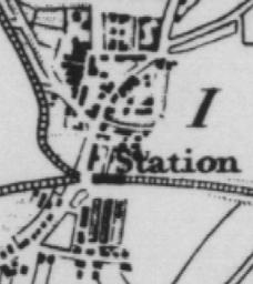
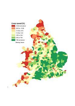
What is a GIS? A GIS is effectively a form of database. What makes it unique is that every item of data in a GIS is linked to a representation of where the data refer to. This is usually in the form of a point, a line, a polygon (representing an area or zone), or a pixel. Thus in a GIS of census data each row of statistical information would be linked to a polygon that represents the district, ward, output area, or tract that the statistics refer to. Similarly, in a GIS of images of historic buildings each image would be linked to a point that shows where the building is located. A GIS is obviously well suited to mapping data but its uses go well beyond this as it allows a researcher to explicitly research the geographical aspects of the data that he or she is studying. What is Historical GIS? Although GIS originated in the Earth Sciences, since the 1990s its use has increasingly spread to historical research such that the field has become known as Historical GIS. One of the original manifestation of this spread was the creation in a number of countries of National Historical GISs such as the Great Britain Historical GIS and the US National Historical GIS. These are systems that hold changing administrative boundaries linked to census and other data published using them. They usually cover most of the nineteenth and twentieth centuries. Increasingly GISs have focused on much smaller areas and on more qualitative sources. Good examples of these include the Valley of the Shadow project and the Salem Witchcraft project. Both of these projects created large archives on two counties on the eve of the American Civil War (the Valley of the Shadow) and the village of Salem, Massachusetts around the time of the witchcraft trials. Both independently saw the need to add a GIS component to their archive partly to help structure the data, and also because they realised that geography was important to their understanding of their research questions. Historical GIS can also be used to structure map libraries such as is demonstrated by the work of David Rumsey, and is extremely good at presenting complex spatial information such as census statistics in an intuitive way. Social Explorer provides an excellent example of this based primarily on American data. A number of organisations have also been important in the development of Historical GIS. In particular, the Social Science History Association and the Electronic Cultural Atlas Initiative. More information on all of these projects and organisations can be found under the links on the left of this page. |
(c) Ian Gregory, 2007 |